
Category:Communication maps of Europe
Media in category "Communication maps of Europe"
The following 18 files are in this category, out of 18 total.
-
 Average mobile screen time.jpg 1,414 × 1,598; 295 KB
-
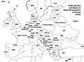
 Blank Map of Europe.png 2,370 × 1,740; 149 KB
-
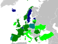 Cell Broadcast map.svg 680 × 520; 799 KB
-
 DAB coverage map.jpg 3,812 × 3,436; 3.95 MB
-
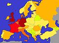
 Doublage en Europe.png 1,105 × 975; 37 KB
-
 EuHighResRadio.jpg 2,220 × 1,646; 827 KB
-
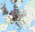
 European detail map of Flickr and Twitter locations - Flickr - Eric Fischer.jpg 2,775 × 1,992; 1.11 MB
-
 Existing and Planned Submarine Cables Connected to Europe October 2022.png 1,079 × 718; 1.03 MB
-
 Facebook Statistics Europe 2009.png 461 × 285; 39 KB
-
 Facebookbenutzer.jpg 974 × 718; 148 KB
-
 Linkedin users in European countries.png 1,414 × 1,562; 784 KB
-
 Submarine cables map Europe 20 May 2023.png 882 × 708; 597 KB
-
 WiGLE map Europe 2019.png 796 × 842; 169 KB
-
 Zasieg PCSK225.png 2,000 × 1,886; 1.87 MB
-
 Zasieg PCSK225V3.png 1,000 × 943; 655 KB
-
 Zasięg nadajnika PCSK225.png 1,106 × 1,055; 718 KB
-
 Zasięg sygnału PCSK225.png 2,211 × 2,109; 2.18 MB
-
 Карта панъевропейской сети RETN.png 1,675 × 1,001; 1.1 MB


