
File:European trafficregions.png

Size of this preview: 616 × 600 pixels. Other resolutions: 247 × 240 pixels | 493 × 480 pixels | 942 × 917 pixels.
Original file (942 × 917 pixels, file size: 32 KB, MIME type: image/png)
Captions
Captions
Add a one-line explanation of what this file represents

|
File:Countries of Europe driving on the left or right.svg is a vector version of this file. It should be used in place of this PNG file when not inferior.
File:European trafficregions.png → File:Countries of Europe driving on the left or right.svg
For more information, see Help:SVG. |
 |
Summary
[edit]| Description |
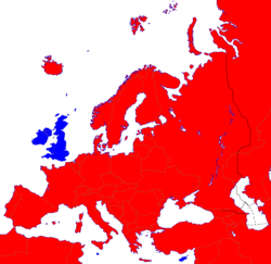
English: Right- and left-hand traffic in Europe.
Right-hand traffic Left-hand traffic Svenska: Höger- och vänstertrafik i Europa. Högertrafik Vänstertrafik |
||||||||
| Date | |||||||||
| Source | Own work | ||||||||
| Author | Daddodd~commonswiki | ||||||||
| Permission (Reusing this file) |
|

File history
Click on a date/time to view the file as it appeared at that time.
| Date/Time | Thumbnail | Dimensions | User | Comment | |
|---|---|---|---|---|---|
| current | 22:11, 23 August 2022 | | 942 × 917 (32 KB) | Рагин1987 (talk | contribs) | More correct visualization of the dividing line on the territory of the Caucasus Range |
| 07:12, 27 January 2007 |  | 942 × 917 (66 KB) | Sparla (talk | contribs) | ||
| 15:30, 13 November 2006 |  | 942 × 917 (66 KB) | Daddodd~commonswiki (talk | contribs) | <font color="#B41624">Red means driving on right.</font><br /> <font color="#2C2EDC">Blue means driving on left.</font><br /> {{GFDL}} |
You cannot overwrite this file.
File usage on Commons
The following page uses this file: